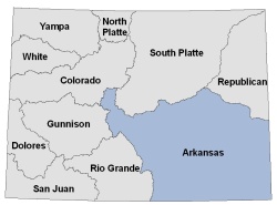
Arkansas River DSS
The Arkansas River Decision Support System (ArkDSS) is the final major basin DSS to be completed in Colorado. The feasibility study for the DSS was completed in 2011 and work started in 2017. This basin offers many unique challenges in terms of data collection and modeling with its complex administration and Compact requirements.
ArkDSS Task 1.1a - Canal Mapping
ArkDSS Task 1.1c - Historical Wells
ArkDSS Task 1.1d - Soil Available Water Capacity
ArkDSS Task 1.2
- Task Memo
- Historical Aerial Photos (1953, 1975, 1988, 1998)(174GB download)
ArkDSS Task 1.3 -Historical Irrigated Acreage Snapshots

ArkDSS Task 2.1 - Water Commissioner Interviews The objectives of these meetings were to 1) develop an initial basin understanding, 2) determine what diversion and reservoir structures should be included in future modeling efforts, and 3) determine which reservoirs and diversions warrant more detailed investigation and technical documentation. These objectives support Task 3 Consumptive Use Analysis and Task 4 Surface Water Modeling.
ArkDSS Task 2.4 - Development of Structure Irrigation Parameters
ArkDSS Task 2.5 - Errant Data Points Submittal
ArkDSS Task 2.7.1 - Driller Log Database
- Task Memo
- Appendix A - RockWorks
- Appendix A - Database
- Appendix B - Data Dictionary
- HI Pumping and Acres and Crops Files - Task Memo
ArkDSS Task 2.8 - URFs
ArkDSS Task 3.2-3.5 - Climate Data, Crop Coefficients, Climate Stations, Reservoir Evaporation
Other documents and data from the ArkDSS project will be listed as they become available.